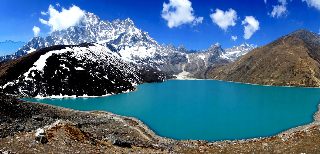
The Mount Everest or Khumbu region of Nepal is justifiably famous on several counts; hosting both the world's highest mountain and the Himalayan kingdom's most famous ethnic group, the friendly and very hospitable Sherpas. It is also home to Tengboche monastery - one of the highest and most spectacularly situated monasteries in the world. Indeed, Buddhism's calm and gentle philosophy pervades the whole area in the form of prayer wheels, shrines, prayer walls and fluttering, brightly colored prayer flags, and of course, in its people. Their festivals and ceremonies are practiced today, as they were centuries ago, Khumbu is named after their most holy of mountains - 'Khumbila' - and to the Sherpa people everything within this world is sacred; every lake and mountain is the abode of living deity. The 5 lakes of Gokyo are thought to be especially powerful and every Sherpa hopes to go there at least once in their life. From here the views of Everest and Nepal's largest glacier, the Ngajumba, are unsurpassed.However, Everest, or Sagarmartha, as it is called locally, does not stand alone in this tremendous mountain world. It is surrounded by her smaller and often more graceful friends - Lhotse, Nuptse, Cho Oyu, Kangtega, Tramserku, Pumori, Cholatse and the sensational Ama Dablam, considered by many to be the most beautiful in the world.
The Yeti too, is said to room these high mountain valleys, along with snow leopard, red panda and musk deer. Nepal's national bird, the brilliantly colored Danphe(lophophoreus) pheasant, is also common in these parts, as are mountain goats and Himalayan Tahr. Overhead, eagles and lammergeier soar on the thermals, whilst the forests and mountain meadows are olive with alpine blooms, azaleas and rhododendrons.
Highlights of the trek
This trek is suitable for fit and experienced hill-walkers with the stamina for 14 days on the trail. The trek should also appeal to those with an interest in Buddhism and the culture of these well-loved high altitude people. Maximum altitude: Gokyo Ri 5350m, sleeping at Gokyo (15J20ft/4791m)
Fly to Lukia, trek to Phakding (8700ft/2652m). Early morning transfer to the domestic airport for an exhilarating 30 minute flight to Lukla (9350ft/2860ml in the heart of the Everest region. Upon arrival, take breakfast at a local lodge. Acclimatization is important, so the day's walk is a short one, along the Dudh Kosi River to the village of Phakding, where you stay in a comfortable lodge. Along the way we pass through Ghat village and look up the river volley to the enormous south face of Kusum Kanguru. (approx. 3 hours). Ascent by plane 1400m.
Continuing along the Dudh Kosi, enter the Sagamartha National Park at Jorsale (9100ft/2774m) and then, after crossing one of Nepal's most famous and dramatic suspension bridges, trek up the hill to NamcheBazar 11,300ft/3446m). Today's walk takes about 6 hours. Namche Bazaar is often referred to as the capital of the Sherpa region and is the true gateway to Everest. With the Bhote Kosi river far below to the south and the Dudh Kosi to its east, Namche forms a natural amphitheatere around the hill side. Across the Bhote Valley Mount Kwangde rises to over 7000 metres and is a wonderful sight at down, when the rising sun points it with a fiery orange glow. The mighty Thamserku is visible across the volley and from the nearby viewpoint you'll see mountain after mountain reveal itself- Tawoche, Thamserku, Kangtega, Ama Dablam, Lhotse and of course, rising above them all-Everest itself Ascent : approx. 796m.
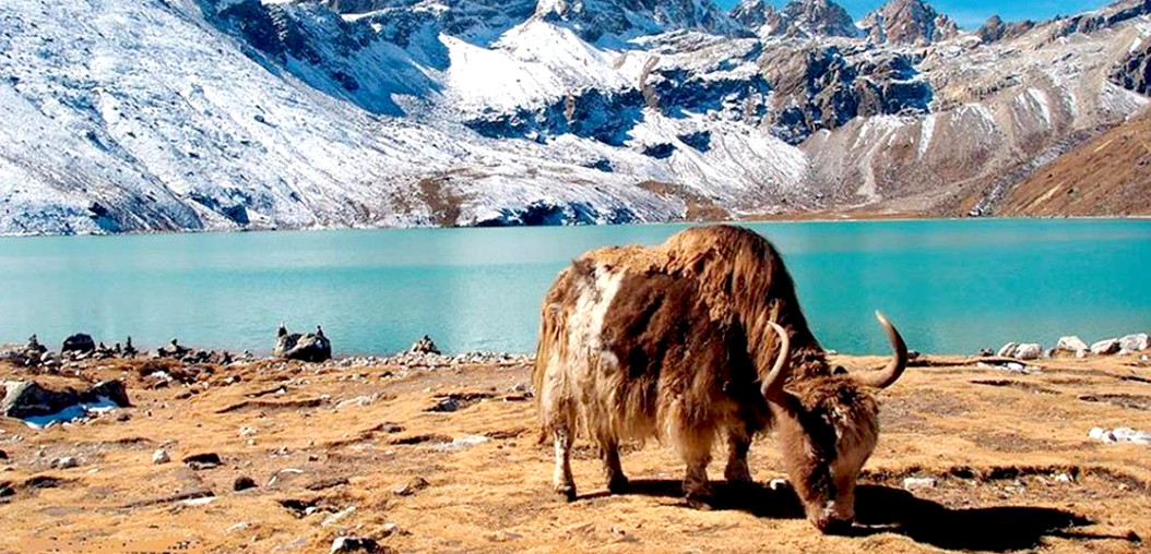
There are lots of things to do in Namche, including shopping, sending emails and eating at the Everest Bakery. On Saturdays there is a large market or 'Haat Bazaar' in the middle of town, which attracts people from far and wide to trade and sell their products. Set in a grove of juniper trees, Namche has its own monastery and there ore several very old stupas scattered around the hill-side. Many people just find a good place to sit and watch the mountains or the comings and goings of the yak herders and their animals and the unfolding Sherpa life, but those who would like a walk can hike out along the Bhote Kosi valley for on hour or so towards Thame, where there is a good chance of spotting Himalayan Thar.
Two hours, this is one of the real beauty spots of the trek, set beneath the outspread arms of Ama Dablam and directly beneath the giant rock slopes of Khumbila, the abode of the patron god of Khumbu. Pine and dwarf azaleas dot the landscape, framing the giant snow peaks to the north. Look out for red panda and pine martin in the woods. Khumjung village also has on interesting monastery and a school built by Edmund Hillary, not to mention the delights of the Everest Bakery. Ascent: approx. 340m.
5 hours, The trek now takes you below the towering slopes of Khumbila (5761m). We cross the Mong La pass at 4000m before descending steeply to the Dudh Kosi. The trail then climb steeply through a beautiful rhododendron forest, giving way to junipers and pines as the elevation increases. The views of Tawoche (6542m.) and Kangtega and Tramserku are superb. This area is used as summer yak pasture and has no permanent settlements. Lodges provide basic amenities.the starlit panoply in the night sky above is truly spectacular Ascent: approx. 320m.
3 Hours, It was on the short but steep uphill walk, following the west bank of the Dudh Kosi that a yeti was said to have killed 3 yaks and attacked a Sherpa woman in 1974 From the ridge above Machhermo there are tremendous views of Kangtega and Cho Oyu (8153m.), and an optional afternoon walk follows this ridge to a point called Windy Peak. Ascent: approx. 310m
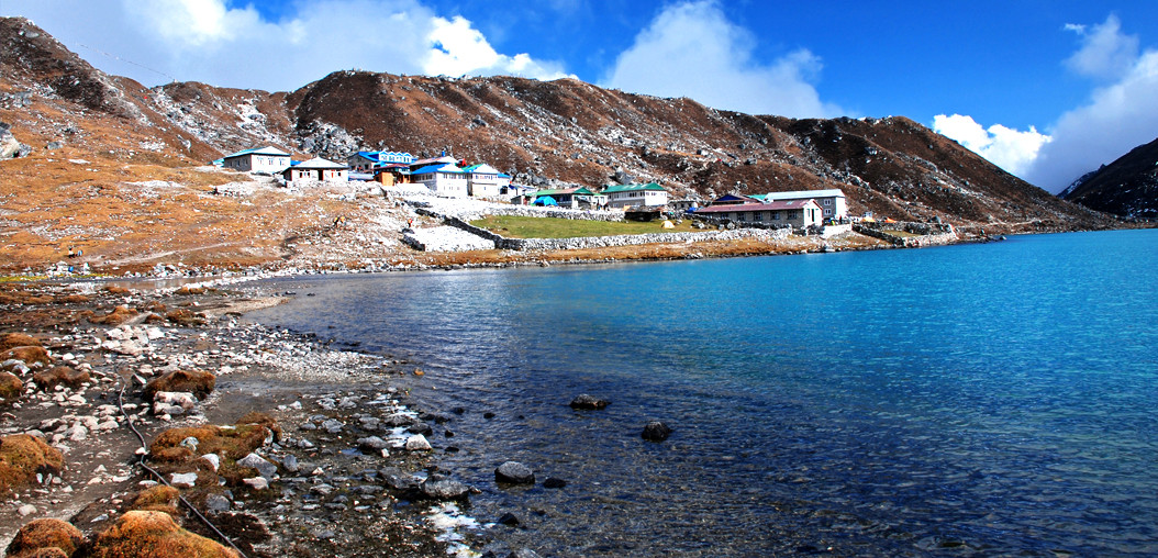
4 hours. After reaching the terminal moraine of Nepal's largest glacier, we arrive at the first of the sacred lakes, where a large family of Brahminy ducks have resided for several years.The next day is spent in the area, and this gives you the chance to ascend the nearby Gokyo Ri (5350m), which takes about 3 hours. You will be reworded by sensational views of the nearby 8000m peaks of Everest, Lhotse, Cho Oyu and Makalu, surrounded by an ocean of smaller, but no less impressive, Himalayan summits. Ascent: approx. 240m
6 hours, After crossing the Dudh Kosi below the glacier we follow the eastern side of the Gokyo volley to Phortse, perched high on a shelf above the Dudh Kosi. This is an exhilarating walk, with new and stunning views along the way. This is one of the older and less visited Sherpa villages and a favourite haunt of musk deer, Himalayan thar and Danphe pheasant. Descent: 1000m.
3 hours, we cross the Imja Khola and visit one of the world's highest monasteries, with its incredible views of the Everest massif, Tengboche Monastery was built in the 1920s, but the original was destroyed in the earthquake of 1934. Tragedy struck again in 1989, when fire gutted the building. Today an impressive new monastery stands on the site and the Buddha image contained within is one of the largest and most beautiful in Nepal. Ascent: 67m
4 hours, Descend the south side of the ridge, cross the Dudh Kosi on a fine bridge and ' then wind your way high above its west bank, before Namche comes into view. Afternoon to relax or explore. Descent: 427m
3 hours trek back to the beginning point of Lukla.
Transfer to hotel. Afternoon leisure.
Your safety is of paramount concern whilst traveling with Himalayan Trailfinder. Please note that your leader has the authority to amend or cancel any part of the itinerary if it is deemed necessary due to safety concerns. Every effort will be made to keep to the above itinerary; However, as this is adventure travel in remote mountain regions, we cannot guarantee it! Weather conditions, health condition of a member, unexpected natural disasters etc, can all contribute to changes in the itinerary. The leader will try to ensure that the trip runs according to plan, but please be prepared to be flexible if required.
Tims card and national park entry permit.
Experienced guide and porter one for two guests.
All ground transportation during the trip.
Three meals a day (Breakfast/Lunch/Dinner) and accommodation in local family house/lodge.
Emergency rescue arrangement.
First aid kit.
Water resistant kit bag.
Walking poles.
High quality Italian camping equipment (Ferino, La Sportiva, Salewa)
Down sleeping bag, Down jacket air mat on request.
Experienced guide and porter one for two guests.
Drinks, beverage water
Donations, tips
Personal expenses
Visa fee on arrival