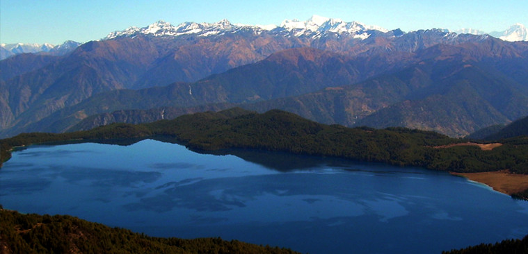
Rara Lake lies in the remote far northwest of Nepal .The lake is surrounded by snow capped mountain ranges and great Himalayan hill sides which are peaceful and beautiful. The region around Jumla and Rara Lake is still relatively unexplored by trekkers. Our trek starts at Jumla, the largest upland hill town in western Nepal. Rara is located at an altitude of 2980m. An outstanding snowcapped panorama of Dolpo and Tibetan mountains overshadows the scene across the deep clear waters of the lake. The National park is inhabited by Himalayan black bear, leopard, block panther, musk deer, red panda, wild boar. Rhesus and languor monkeys and numerous species of birds. The final four days of the trek offer superb views over Mugu, the southern mountains of Humla and the border ranges of Tibet. The trail takes us through grassy alpine pastures and remote villages, before descending steeply off the second pass to Jumla. From here, we fly back to Kathmandu via Nepalgunj.
Highlights of the Rara trek
Unsurpassed views of Rara Lake and mountain scenery, chance of spotting wildlife such as musk deer and black bear, ruins of the Malla dynasty's old palace.
Fly to Nepalgunj, a small town near the Indian border in the Terai region of Nepal, and stay overnight in this transit city.
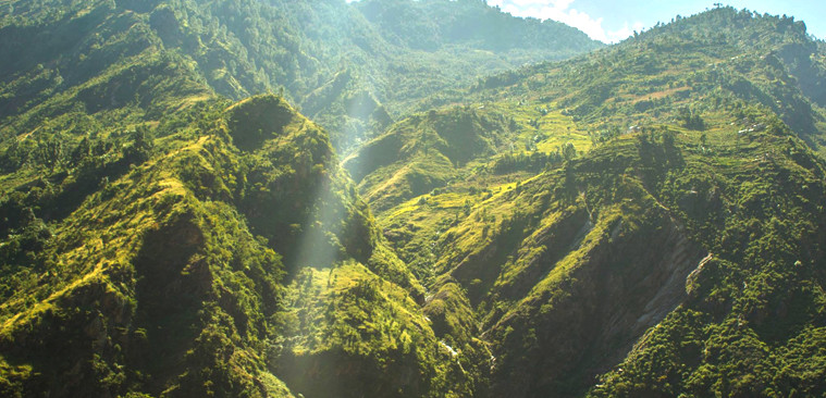
Starting point for Rara trek. Fly to North from Nepalgunj crossing several hilly regions. If the weather is clear, you can enjoy good views of snow-capped mountains to the east and west. Jumla town is in a delightful valley and here are the highest limits of paddy cultivation, growing red rice. The town is the administrative headquarter of the entire Karnali zone and Jumla district. Local regulations have declared Jumla a dry district, so no alcohol is available
We start our trek to Rara lake by following the north bank of the Tila Khola river and then turn north following the Chaudhabise Khola passing through fields and pine forests. We will ascend towards Padmara valley. Our trail keeps following the river until we arrive at the small village of Uthugaon, where we will have a good campsite close to the school on the opposite site of the river (4 hrs).
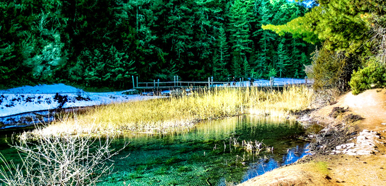
After our breakfast we will follow the trail through this narrow canyon to the village of Padmara at 2900 m. Our path then climbs up to the Khali Lagna pass at 3550 m through a deep forest of pines, spurches and firs. Then the trail descends gently through mixed forest of spruces, birches and rhododendrons to arrive at our campsite at Danphe Lagna. The colourful national bird of Nepal (the Himalayan monal, or impeyan peasant) has been spotted there many times close to our campsite (4 hrs).
The trail descends gently alongside the stream to two bhattis (teashops) at Tharamara (3280m) and the descending steep part of the trail is passing through fir, birch, and walnut and bamboo forests. After crossing a bridge at 2680 meters, we follow the river downstream before starting a serious climb passing some water-driven mills to Kabra. Here is a huge overhanging rock which is the source of silajit, a mineral which is believed to have "healing" properties. It is exported to India and people believe that 'there is hardly any curable disease which cannot be controlled or cured with the aid of silajit. 'Our steep climb continues for a while and then levels out before Bhara (classic Tibetan style village). After this village we descend to the Chauro Khola river to the village of Chautha (6 hrs).
Our trail continues to follow the stream uphill to Bhulbule, the Rara National Park entrance station at 3130 meters. Our path keeps on climbing up gently to Ghurchi Lagna pass (3450m) which is covered with an assortment of chortens (round stone Buddhist monuments) and prayer flags. From the pass the route descends gently before dropping down precipitously through spruce forests. The path level is about 2900 meter and continues more or less at the same level to the small settlement of Dhotu where we camp (5-6hours)
It is a short, pleasant trek with beautiful views to the north. From Dhotu we traverse a steep north facing slope and cross a series of fields down to a small stream. After crossing the bridge, we climb up to the Thakuri village of Jhyari (2630m). From Jhyari, we climb steadily up through cedar forest to a huge meadow atop a 3050 meter ridge with great overhead views of Rara Lake. We will follow the trail along to the northern side of the Lake, where the headquarters and the camping ground are situated (4 -Bhrs).
Rara Lake is the largest lake in Nepal. It is almost 13 km around the lake and a day devoted to walking around it is well spent. Among the mammals in this region are Himalayan bears, serows, gorals, musk deer, pandas and both rhesus and langur monkeys. The 170 meter deep lake is a habitat for otters and an important resting place for migrating waterfowl.
From the bridge at the western end of Rara lake the trail will follow the Khatyar Khola river. We keep following this river slowly descending before we climb up a small trail surrounded by pine, spruce and rhododendron forests, We follow our path dropping into the Ghatta valley heading towards the small settlement of Gorosingha where there are several excellent campsites (6hrs).
The route keeps heading down the Ghatta valley following the Sinja Khola river downwards to Sinja, From the 12th to 14th century, Sinja was the capital of the Malla dynasty that ruled western Nepal. The ruins of the old palace can be seen across the river. There is an interesting temple here dedicated to Bhagwati, the goddess of justice who rides a tiger (5-6hrs).
From Sinja, the trail crosses the Sinja Khola on a wooden cantilever bridge. After passing a few small villages, the trail passes on back and forth across the river on a series of quaint log bridges. Most of the trail forest of pine, birch and oak and fields of barley and corn. Then the trail makes a steep climb to Jaljala Chaur, a gigantic meadow full of horses (6 hrs).
Keep climbing through forest to another meadow, just below the ridge at 3510m, followed by a pleasant descent to Jumla (4 hrs).
Overnight stay at hotel.
Your safety is of paramount concern whilst traveling with Himalayan Trailfinder. Please note that your leader has the authority to amend or cancel any part of the itinerary if it is deemed necessary due to safety concerns. Every effort will be made to keep to the above itinerary; However, as this is adventure travel in remote mountain regions, we cannot guarantee it! Weather conditions, health condition of a member, unexpected natural disasters etc, can all contribute to changes in the itinerary. The leader will try to ensure that the trip runs according to plan, but please be prepared to be flexible if required.
Tims card and national park entry permit.
Experienced guide and porter one for two guests.
All ground transportation during the trip.
Three meals a day (Breakfast/Lunch/Dinner) and accommodation in local family house/lodge.
Emergency rescue arrangement.
First aid kit.
Water resistant kit bag.
Walking poles.
High quality Italian camping equipment (Ferino, La Sportiva, Salewa).
Down sleeping bag, Down jacket air mat on request.
Drinks, beverage water
Donations, tips
Personal expenses
Visa fee on arrival